Mapping out a route for a skating raid
You cannot get into a long distance skating raid without at least a little preparation: food, clothing, maps and routes are many parameters that should be taken into consideration. Unless you wish to try your luck in total adventure, here are a few tips to map out your route...
Par alfathor
Tips to successfully map out your route
 Mapping out your route before setting off on an adventure is not an extravagance. Skaters are vulnerable on roads against car drivers, probably even more than cyclists because they are less legitimate to use the road. Indeed, skaters don not have a status worthy of the name, they are only tolerated on cycle lanes, pavements and roads.
Several parameters to be taken into consideration for the mapping out of your route:
- Volume of car traffic on roads
- Variety of relief
- Quality of surfaces
- Proximity of emergency services and fallback solutions in case of a problem (train stations, watering places, food…)
- A roof for the night! (hotels, accommodation, campsites, etc.)
Buy recent maps
Infrastructures are in constant evolution: 15% of taxes would be modified each year according to the stats of GPS manufacturers. A secondary road may well be turned into a main road, or a two-lane roadway become a dual two-lane roadway, which would make them impracticable on skates!
Moreover, road sections may have been created or suppressed. It is why having an updated map is vital.
Do not forget that there are also cycle lane maps. They will come handy to secure your route. Warning: Not all cycle lanes are practicable on skates!
Last but not least, even if you have a GPS, make sure you always have a paper map on you in case it runs out of battery.
What is an isometric map?
On a map, isometric lines connect all the points that are at the same altitude. The closer they are, the faster you gain altitude. The further they are, the smaller the differences in height.
This type of map may prove very useful in order to determine which path to take across a particular area.
Tip: Most of the time, if you follow watercourses, you should reduce the risks of finding yourself at the foot of a mountain.
On the other hand, those routes are not always the shortest, streams and rivers are often quite winding. All in all, it is up to you wether you want a direct route or or the long way round.

Favor secondary roads
Main axes often have more traffic and are therefore more dangerous. Most of the time you will have less to worry about on secondary roads, which are less travelled because less direct. We would strongly advise you to avoid main roads and other dual two-lane roadways. An efficient technique not to suffer from traffic is to get away from axes connecting cities together. Instead of going from one big city to another, cut through the area you are crossing and favor medium sized towns and villages.
 In addition, you will probably have unforgettable encounters! The tranquility of country roads is favorable for self-reflection, introspection and meditation…
Do some frequentation research
Preparing a raid takes some time. Several weeks, even months are necessary in order to secure your getaway, especially if you go solo.
Why not contacting the local clubs of the areas you cross to ask about their road traffic?
Maybe you will find welcoming people that will offer you accommodation and/or skate part of the way with you.
Use Google Earth to optimize your route
Satellite tracking can tell you a great deal about the configuration of the roads you intend to take. You can even spot practicable cycle lanes!
The principle is simple:
- Pin your paper map on a wall
- Put one pin at your start and one at your arrival
- Stretch a thread between the two in order to draw the most direct way
- Add a few pins where you intend to pass by or stop over
- Note the axes you intend to take
- Go back on Google Maps and switch to satellite mode to track your route
The process is long but very useful to avoid surprises!
Rough roads are manageable
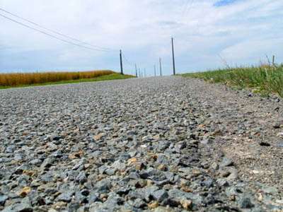 Don’t fool yourself, the number of rough roads is still more important than that of perfect coatings. On a 750 km raid between Paris and Orthez, we had more than 400 km of damaged grounds.
You have to adjust your skating, use bigger wheels, grin and bear it.
Favor green lanes
Why not integrating a green lane in your route? Their number increases every year, use them even if it implies making a slight detour.
In the end, it may become possible to cross the country without using roads.
Scout your route
Make the most of a holiday departure, of a weekend, etc. to scout the roads of your future journey.
Instead of taking the highway to save time, take the charming country roads that cross our beloved country. Then you can evaluate the traffic, the relief, the quality of coating, find stopover places…
Make a roadmap
Then we would advise you to make a roadmap for each step, just like rally drivers. Write down the main changes of direction, the names of the roads, the notable spots, the mileage: You won’t have to constantly take off the map while you are on the road.
And why not a GPS?
Nothing prevents you from using a GPS on D-day… But if you leave for several days, it will quickly run out of battery. In this case, buy an additional battery or a solar charger. We would advise you to keep the GPS in case you get lost. Modern smartphones enable you to take pictures but also to find your way if needed.
Leave a trace of your route to your close relations
If you feel like going for a solo journey, better be safe than sorry. Don’t forget to leave a duplicate of your route to your close relations so that they can find you in case of a problem, or indicate your position to the emergency services.
Why not doing a little tourism?
Countless wonders that will fill you head with images hide round a bend, in the depths of our country. Nothing prevents you from taking a few minutes to enjoy the view at a panoramic point, have a break at the foot of a castle sited on a rocky spur, enjoy the tranquility of a shady pond. Your journey may very well be brightened up with a few touristic breaks.
Safe trip!

Useful links
Green lanes on spotland.fr
French Association of cycle and green lanes
Geoportal
Google Maps
750 km from Rambouillet to Orthez in 7 days
Translation: Chloe Seyres
Photos : Alfathor